Geology and Geomorphology of Bahía de Los Angeles Region

The geological history of Bahía de Los Angeles is linked to Baja California Peninsula. Fault zones, sediment deposits, and plate shifts shaped the region. Islands formed during Pleistocene glaciations. Soils are eutrophic regosols, susceptible to erosion.
Geology and Geomorphology of Bahía de Los Angeles Region
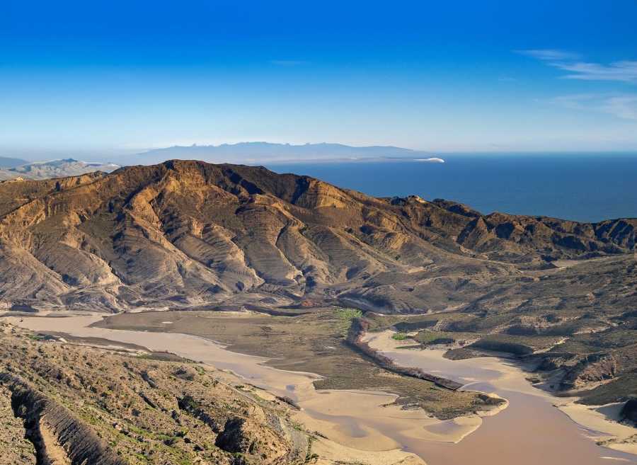
The stunning landscape of Bahía de Los Angeles, shaped by fault zones and plate shifts over millions of years.

The Bahía de Los Angeles region, located in Baja California Peninsula, Mexico, holds a rich geological history closely intertwined with that of North America's west coast. This area boasts diverse islands, each with unique origins, geological ages, and distances from the mainland. Understanding the geological and geomorphological features of this region provides valuable insights into the earth's past and helps us appreciate the fascinating processes that shaped the landscape we see today.

The Geology of Bahía de Los Angeles

The stratigraphy of the Bahía de Los Angeles region presents a complex picture, with a metamorphic basement consisting of mafic schists and Palaeozoic metapelites. Additionally, the area showcases the Ballenas Group, a sequence located in the western part of the Ballenas Channel. This group represents a continental slope to basin depositional environment and consists of a mix of calcareous mudstones, bioclastic packstone, shales, flints, flysch deposits, conglomerates, and alkaline pillow basalt.


The geological features in the region are heavily influenced by fault zones. For instance, the Ballena, Partida, and San Lorenzo fault zones separate Isla Angel de La Guarda and the San Lorenzo Archipelago from the Baja California Peninsula. These fault zones have experienced a seven-degree slip oblique to the spreading direction of the Guaymas zone, indicating their significance in shaping the landscape. The movement of tectonic plates from one fault zone to another, both parallel and overlapping, contributed to the separation of Isla Angel de La Guarda from the Baja California Peninsula around two million years ago.

Sediment accumulation plays a vital role in the geological evolution of this region. Coarse sediments cover the valley rifts in the Ballenas Fault zone, demonstrating continuous subsidence. The primary contributors of sediments to the depressions are the rivers flowing from the Sierra Madre mountains of Sonora and Sinaloa, as well as the Colorado River for the northern Gulf. In the central Gulf, a thriving plankton population in highly productive waters results in a substantial rain of pelagic debris, with diatom fragments comprising about half of the sediments in the Guaymas and San Pedro Martir basins. However, despite deep depressions, semi-arid mountainous terrain, and productive waters, the San Lorenzo and Ballenas fault zones have relatively little sediment cover. The Salsipuedes Basin also lacks significant sediment accumulation, possibly due to continuous removal caused by currents or recent fault activity.

Ancient islands, remnants of Pleistocene glaciations, dot the picturesque waters of Bahía de Los Angeles.
Ancient islands, remnants of Pleistocene glaciations, dot the picturesque waters of Bahía de Los Angeles, showcasing geological wonders.

Formation of Bahía de Los Angeles Islands

The intriguing islands of Bahía de Los Angeles came into existence when the waters of the Gulf of California filled the deep valleys between mountain peaks during Pleistocene cyclic glaciations. Notably, the deepest underwater valleys lie between Los Gemelitos and Cabeza de Caballo islands, suggesting they might have been filled during the original flood around 10 million years ago. The present configuration of the Bay, where water covers much of the former shallow marine areas, is estimated to have occurred around 10 to 15 thousand years ago during the last ice age.

The region's geomorphology owes its characteristics to the prevalence of granitic rocks, giving rise to undifferentiated residual soils known as eutrophic regosols (Re). These soils possess a sandy or sandy crumb texture and are shallow with low nutrient and organic matter content, making them less fertile and more susceptible to erosion. Natural erosion continually affects these soils, often in association with calcareous fluvisols (Je) and lithosols (L).

The geological and geomorphological history of Bahía de Los Angeles is a captivating window into the past of the Baja California Peninsula and the western coast of North America. From the complex stratigraphy and fault zones that shaped the region to the formation of its unique islands during Pleistocene glaciations. Every aspect of its geological story tells us about the dynamic processes that have sculpted the landscape over millions of years.

This understanding not only enhances our knowledge of the earth's history but also offers valuable insights for land management, conservation efforts, and responsible development in the region. Bahía de Los Angeles stands as a testament to the remarkable forces of nature and serves as a reminder of the importance of preserving our planet's geological heritage.

Sources: SEMARNAT and CONANP