What Is a Cenote? The Geology Beneath the Yucatan Peninsula
Beneath your feet lies a 524-kilometer underwater cave system—the longest on the planet. The water you're looking at sustained the Maya for millennia. And that perfectly circular opening? It might be connected to the asteroid that wiped out the dinosaurs.

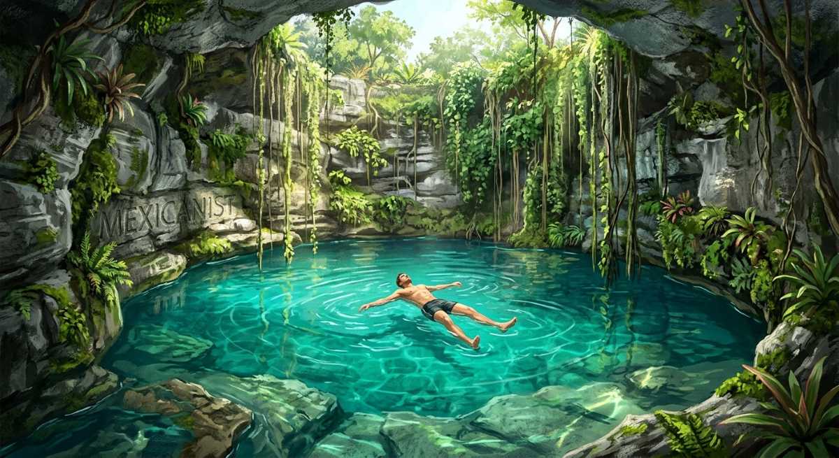
You're standing at the edge of a perfectly circular hole in the jungle floor, staring down into water so clear it looks like liquid glass. Sunlight beams through the opening like something out of an Indiana Jones movie, illuminating stalactites that have been growing for hundreds of thousands of years. Welcome to the surreal world of cenotes—the Yucatan Peninsula's greatest geological treasure and your ticket to understanding one of Earth's most fascinating underground landscapes.
These aren't just pretty swimming holes. Beneath your feet lies a 524-kilometer underwater cave system—the longest on the planet. The water you're looking at is part of a freshwater lens that sustained the Maya civilization for millennia. And that perfectly circular opening? It might just be connected to the asteroid impact that wiped out the dinosaurs 66 million years ago. Welcome to the cenote, where geology, history, and adventure collide in spectacular fashion.
What Exactly Is a Cenote?
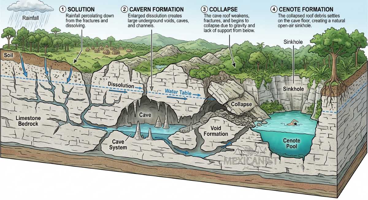
Let's start with the basics. A cenote (pronounced seh-NO-tay) is a natural sinkhole or pit created when limestone bedrock collapses, exposing the groundwater underneath. The word comes from the Maya term ts'onot, meaning "hole with water"—and for the ancient Maya, these weren't just geological features. They were sacred portals to the underworld, known as Xibalba, and the primary source of fresh water in a region with almost no surface rivers or lakes.
Here's what makes cenotes truly remarkable: the Yucatan Peninsula is essentially a giant limestone sponge. Rainwater doesn't run off into rivers like it does elsewhere—it sinks straight through the porous rock, creating an enormous underground freshwater aquifer. Over thousands of years, this slightly acidic rainwater dissolves the limestone from below, creating caves and voids. Eventually, the ceiling gets thin enough that it collapses, and boom—you've got yourself a cenote.
"The Yucatan Peninsula is home to an estimated 6,000 to 10,000 cenotes—the greatest concentration of these geological formations anywhere on Earth."
The numbers are staggering. The Yucatan Peninsula is home to an estimated 6,000 to 10,000 cenotes—the greatest concentration of these geological formations anywhere on Earth. According to Wikipedia and regional surveys, approximately 6,000 of the world's 7,000 known cenotes are located in Mexico, making this region unparalleled for cenote exploration.
The Limestone Karst System
To understand cenotes, you first need to understand karst topography—a landscape shaped by the dissolution of soluble rocks like limestone, dolomite, and gypsum. The process, called karstification, occurs when rainwater (which is naturally slightly acidic due to dissolved carbon dioxide) seeps into cracks in the rock and slowly eats away at it over geological time scales. This creates the characteristic features of karst landscapes: sinkholes, caves, underground drainage systems, and those stunning stalactites and stalagmites that make cave exploration so magical.
The Yucatan Peninsula is essentially one enormous karst platform—a flat-lying limestone slab that was once submerged beneath a shallow prehistoric sea. According to geological research published in the Journal of Biogeography, the peninsula as we know it began emerging from the ocean during the Eocene epoch, roughly 56 to 34 million years ago. The limestone itself consists of calcium carbonate deposited over tens of millions of years as sediments from ancient marine organisms—shells, corals, and other sea life that accumulated on the ocean floor.
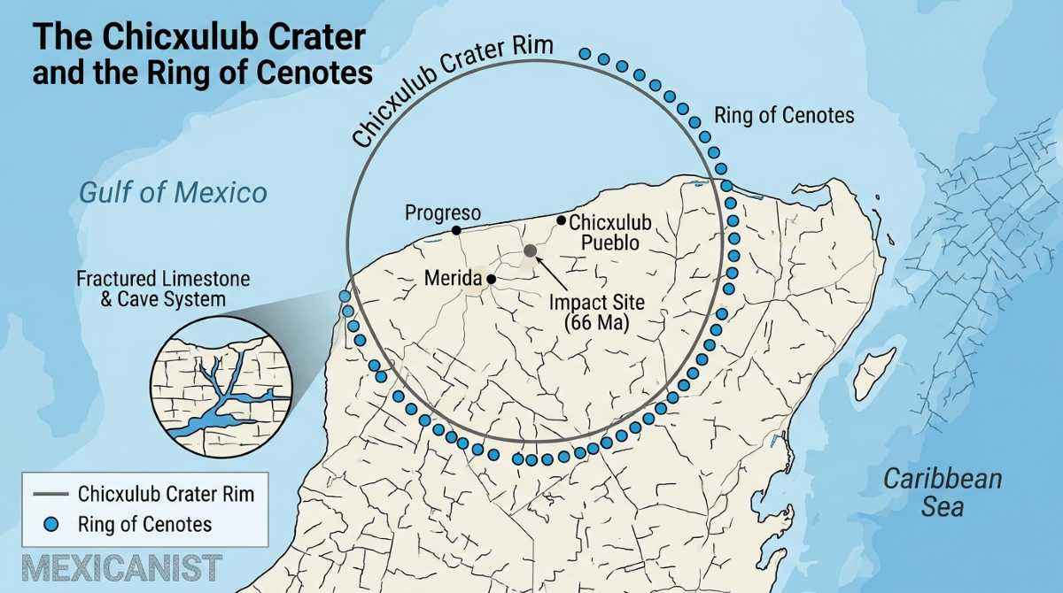
Here's where the story gets absolutely mind-blowing. The most famous geological feature of the Yucatan Peninsula isn't visible on the surface at all—it's buried beneath it. The Chicxulub crater, named after the small town near its center, is the scar left by an asteroid impact 66 million years ago that triggered the mass extinction event that wiped out the dinosaurs (and about 75% of all species on Earth).
The impactor was enormous—approximately 10 kilometers (6 miles) in diameter. When it slammed into what was then a shallow sea, it created a crater roughly 180-200 kilometers (112-124 miles) wide and about 1 kilometer deep. The energy released was equivalent to billions of Hiroshima-sized atomic bombs. The explosion was so powerful that it fractured the limestone platform to depths of several kilometers, creating zones of weakness that would influence water flow and rock dissolution for millions of years to come.
The Ring of Cenotes—a semi-circular arc of sinkholes stretching across the northwest corner of the peninsula—follows the approximate edge of the buried crater rim. Scientists from Northwestern University and other institutions have confirmed that this ring exists because the asteroid impact created fracture patterns in the underlying rock, and those fractures became preferential pathways for groundwater flow. More water moving through means more limestone dissolved, which means more cenotes. The dinosaurs may have disappeared, but the crater that helped kill them is still shaping the landscape millions of years later.
World's Largest Flooded Cave System
If you drained all the water from beneath the Yucatan Peninsula, you'd reveal something that makes the Grand Canyon look like a roadside ditch. The peninsula sits atop the world's most extensive network of flooded caves—a labyrinth of underwater passageways that cave divers have been mapping for decades, and they're still discovering new connections.
The current champion is Sistema Ox Bel Ha, which as of recent surveys has been mapped to an astonishing 524 kilometers (325.6 miles) of explored passages. That's longer than the entire Grand Canyon is wide. According to Science Alert and IFLScience, this makes Ox Bel Ha not just the longest underwater cave system on Earth, but longer than many famous dry cave systems as well.
Hot on its heels is the Sistema Sac Actun ("White Cave System" in Maya), which held the title briefly after divers discovered a connection between two previously separate systems in 2018. The Guinness Book of World Records recorded Sac Actun at 371.958 kilometers (231.12 miles) when it set the record, though continued exploration has pushed these numbers even higher. The system is famous among cave divers for its stunning formations—chandelier-like stalactites, crystal-clear water with visibility exceeding 100 meters, and the ethereal light shows that occur when sunlight penetrates through cenote openings.
"At 524 kilometers, Ox Bel Ha is longer than the entire Grand Canyon is wide—making it the most extensive underwater cave system ever mapped."
Here's something you'll experience the moment you dive into a cenote: the water isn't uniform. Near the surface, you're swimming in crystal-clear freshwater that's been filtered through limestone. But descend deeper, and you'll hit an invisible boundary where the freshwater meets intruding saltwater from the Caribbean Sea. This is the halocline—a mixing zone where waters of different salinities meet.
The phenomenon is visually striking. Because freshwater and saltwater have different densities, they don't immediately mix—instead, they form distinct layers. When you swim through the halocline, the water appears to shimmer and blur, creating an otherworldly effect that cave divers compare to swimming through liquid glass. Scientific studies have shown that the freshwater lens in the Yucatan Peninsula ranges from less than 10 meters thick near the coast to about 70 meters (230 feet) thick inland, sitting atop denser saltwater that infiltrates from the surrounding seas.
This layered system has profound implications for the peninsula's water supply. The freshwater lens is what the entire region depends on for drinking water, agriculture, and industry. But because the aquifer is so accessible and the limestone so permeable, it's also extremely vulnerable to contamination. A study published in the journal Environmental Pollution noted that the Yucatan's karst aquifer is "highly vulnerable to contaminants" because pollutants can travel rapidly through the underground system with little natural filtration.
Types of Cenotes
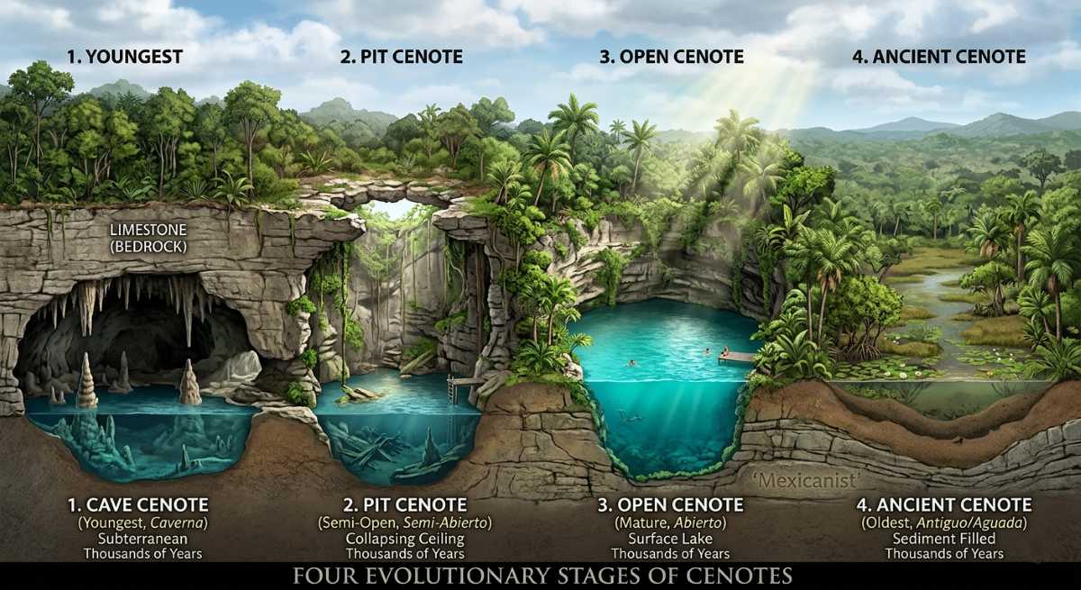
Not all cenotes are created equal. In fact, these natural formations go through a remarkably predictable life cycle that geologists have used to classify them into four main types. Understanding these types isn't just academic—it directly impacts your experience as a visitor, from the adventure level of your swim to the quality of light for your photographs.
1. Cave Cenotes (Youngest)
These are the babies of the cenote world—underground chambers where the ceiling hasn't collapsed enough to create a large opening. Access is typically through a small hole or narrow passage, and the interior is mostly or completely dark. Cave cenotes offer the most adventurous (and challenging) experience, often requiring specialized equipment and training to explore. Examples include many of the caves accessible only to certified cave divers, where you'll find pristine formations that have never been exposed to direct sunlight.
2. Semi-Open Cenotes (Middle-Aged)
As the ceiling continues to collapse, cenotes enter a magical transitional phase. Partial openings allow shafts of sunlight to penetrate into the water, creating those iconic beams of light that photographers travel from around the world to capture. These are among the most visually stunning cenotes, with dramatic contrasts between sunlit areas and shadowed recesses. Famous examples include Cenote The Pit and Cenote Angelita near Tulum, where the light shows are nothing short of spectacular.
3. Open Cenotes (Older)
When most of the ceiling has collapsed, you get an open cenote—a natural swimming pool surrounded by vertical or steeply sloping walls. These are the most accessible and family-friendly cenotes, with plenty of natural light and relatively easy entry points. The water surface is fully exposed, making them ideal for swimming, snorkeling, and introductory diving. Cenote Ik Kil near Chichen Itza is a famous example, though its popularity means you won't have it to yourself.
4. Ancient Cenotes (Oldest)
Given enough time—tens or hundreds of thousands of years—the walls of an open cenote erode and collapse until what remains is essentially a natural lake or pond with gently sloping sides. These "ancient cenotes" barely resemble their younger counterparts, having lost most of their cave-like character. They often support rich ecosystems with fish, turtles, and abundant vegetation. While less dramatic than their younger relatives, ancient cenotes are crucial for local biodiversity and often serve as important water sources for wildlife.
Sacred Portals to Xibalba
You can't talk about cenotes without talking about the Maya. For over 3,000 years, the Maya civilization thrived in a region with almost no rivers or lakes above ground. Their survival depended entirely on the freshwater accessible through cenotes—making these natural formations the literal lifelines of their civilization.
But cenotes were far more than water sources. The Maya believed these natural openings were portals to Xibalba, the underworld realm of the dead and the domain of powerful deities including Chaac, the rain god. The Sacred Cenote at Chichen Itza—also known as the "Well of Sacrifice"—is the most famous example of this spiritual significance.
Archaeological dredging of the Sacred Cenote has revealed an astonishing array of offerings: jade jewelry, gold ornaments, pottery, and human remains. A 2024 genetic study published in Nature analyzed remains from the cenote and found that many sacrifice victims were young boys, challenging earlier assumptions about who was offered to the gods. National Geographic reported that these individuals came from across the Maya world—evidence of the cenote's importance as a pilgrimage site.
"For the Maya, cenotes were not just water sources—they were sacred portals to Xibalba, the underworld realm of the dead."
Today, cenotes continue to hold cultural and spiritual significance for Maya communities, while also serving as major tourist attractions that draw millions of visitors annually. The challenge is balancing tourism with preservation—these delicate ecosystems and archaeological sites require careful management to survive for future generations.
Planning Your Cenote Visit
Ready to experience these wonders firsthand? Here's what you need to know to make the most of your cenote adventure while minimizing your impact on these fragile ecosystems.
Cenote water temperatures remain remarkably constant year-round, typically hovering around 24-26°C (75-79°F)—refreshing but not frigid. Visibility can be extraordinary, often exceeding 30-50 meters (100-165 feet) in the freshwater layer, though it decreases dramatically when you pass through the halocline. Many cenotes have basic facilities including changing rooms, restrooms, and sometimes small restaurants. Entry fees typically range from 50-300 Mexican pesos depending on the site and activities offered.
Most cenotes require you to shower before entering to remove sunscreen, insect repellent, and other chemicals that can harm the delicate ecosystem. Some prohibit any lotions or cosmetics entirely. If you're planning to dive, note that cavern diving (staying within sight of natural light) and cave diving (penetrating beyond the light zone) require different certifications and experience levels. Always dive with a reputable operator and never venture into cave areas without proper training and guides.
The best time to visit is typically during the dry season (November to April), when water levels are lower and visibility is at its best. Popular cenotes can get crowded, especially those near major tourist areas like Tulum and Playa del Carmen. For a more peaceful experience, consider visiting lesser-known cenotes or arriving early in the morning before tour buses arrive.
Protecting a Fragile World
The same characteristics that make the Yucatan's karst aquifer so remarkable—its extreme permeability and rapid water flow—also make it extraordinarily vulnerable to contamination. A study published in MDPI's Water journal characterized the Yucatan Peninsula as "one of the largest coastal and lowland karst regions worldwide" and noted that "this groundwater-dependent region is highly vulnerable to contaminants." Pollution from urban development, tourism, agriculture, and industry can spread rapidly through the underground system with little natural filtration.
Climate change poses additional threats. Rising sea levels are pushing the freshwater-saltwater interface further inland, reducing the thickness of the freshwater lens that the peninsula depends on. Changes in rainfall patterns affect aquifer recharge rates. The challenge is immense, but efforts are underway to better understand and protect this crucial resource.
The Ring of Cenotes has been proposed as a UNESCO World Heritage site, which would provide additional protection and recognition for this unique landscape. Local organizations and international researchers continue to map, study, and advocate for these remarkable formations. As a visitor, you can contribute by following guidelines, supporting responsible tourism operators, and spreading awareness of the cenotes' ecological and cultural significance.
Cenotes are more than geological curiosities or Instagram backdrops. They're windows into Earth's deep history—connecting us to asteroid impacts, ancient seas, and civilizations that rose and fell long before Europeans arrived in the Americas. They're living laboratories where scientists study everything from climate change to evolution. They're sacred spaces where the Maya communicated with their gods. And they're adventures waiting to happen, whether you're a casual swimmer or a dedicated cave diver.
The next time you find yourself peering into that impossibly clear water, watching sunlight dance across submerged stalactites, remember: you're not just looking at a swimming hole. You're gazing into a portal that connects 66 million years of geological history, 3,000 years of human civilization, and the world's largest underground river system. That's the magic of cenotes—nature's gift to the Yucatan, and an experience that will stay with you long after you've dried off.
References
[3] Northwestern University: Ring of Cenotes Research
[4] Guinness World Records: Longest Underwater Cave System
[5] Science Alert: World's Longest Underwater Cave
[6] National Geographic: Maya Sacrifice DNA Study
[7] The Guardian: World's Longest Underwater Cave Discovery
[8] Yucatan Today: Guide to Cenotes